 |
| Click image for enlargement |
You know what the best thing about this plan is? Identifying this 800m zone at the heart of the city.
Ground zero for our urbanization. Get this right and the payoff, evidenced by the experience of other cities, is huge : social, economic, and environmental.
I look at the aerial photo of this zone and find it crazily exciting. If our plan truly reflected the inverted pyramid of mobility priorities from the Transportation Master Plan it would inspire and capture the imagination of the local public, and catch the attention of other cities across the country.
As the plan is now, it and the inverted pyramid of priorities set side by side makes it clear something’s seriously out of whack.
"You can’t add other modes to an already overbuilt private car network. Car infrastructure has to be reduced to accommodate safe equitable walking, accessible mobility for disabled, bicycling, and transit for every age and shape and size of human."
The plan is weakest where it has to be strongest : the pedestrian network. The actions called for are too few, too small and will have little impact.
If the inverted pyramid, codified in City policy, had meaning in the real world, here’s some things that would be evident in the pedestrian network part of the plan :
•
travel lane width reductions (proven to reduce vehicle travel speeds)
•
lane eliminations (road diets, resulting in more equitable share of the street);
•
elimination of “beg buttons” at every City-controlled intersection in the urban core (pedestrians should never have to seek permission to cross on green);
•
elimination of right turns on red lights (research shows high incidence of pedestrian and cyclist injury and death);
•
sidewalk extension lines including zebras across every intersection in the 800m urban zone.
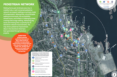
Pedestrian crossing locations : only 4 in the 200m zone, 2 in the 400 m zone, 9 in 800m zone.
Mid-block pedestrian crossings : There are 2 on city controlled streets (one on Terminal MoTI jurisdiction) Skinner St ??
Mid-block zebras should be mandatory with few exceptions on every block of a certain length.
Pedestrian walkway connections between blocks. Sounds great but I have no idea what’s meant by this.
Accessible connection upgrade. There’s one. Have disabled activists confirmed that that’s all that’s needed?
Enhanced pedestrian realm. Details please. This should be one of the primary focuses of the plan.
Times up for empty homilies.
Intersection Pedestrian Operation Improvement I assume this means “beg buttons.”
In a walkable urban zone the pedestrian should never seek permission to walk on green.
Genuine walkability is achievable in this zone and the interventions to do it are low cost and quick. Mystified why staff resist.
I’ve a strong sense that the public support for this urbanization has grown far beyond that of staff’s.
We pause for this editorial : I suspect the process got off on the wrong foot, didn’t understand the nature of the task itself. We’re looking at some of the biggest and most important public space in city. Fixes and modernization of this public space are not at core technical problems, not problems of engineering or problems of landscape architecture, tho both of those are essential once the vision and design have been established.
It’s at core a problem of urban design and the technical process has to be preceded by a process of visioning and design lead by a professional urban designer with first hand experience in establishing walkable urban centres inclusive of the most vulnerable street user.
So… The pedestrian network part of the plan is disappointing. But it’s benign, will do little good but at least will not make things worse.
As for the other parts of the project plan,
bike network good idea and trendy just now.
Pains have to be taken to ensure it doesn’t damage the fragile pedestrian realm. These bike lanes have to be carved out of the over-built car infrastructure. I’m concerned that’s not explicit here.
The
parking study’s an ok idea, I’m sure staff are versed in the research and writing of UCLA urban planning prof
Donald Shoup. Properly managed it’s possible to reduce its supply freeing important downtown real estate for more productive uses.
There are two areas where I have reason to fear what might be hiding in the weeds : the
transit plan should be a separate study not rushed as here and
absolutely not to include a traffic roundabout between downtown and our waterfront. Roundabouts are dangerous and uncomfortable for pedestrians and cyclists and there’s no place for one in a walkable urban core.
And lastly the key
intersection redesigns. The big ticket item, 100s of thousands of dollars I imagine, and if they end-of-the-day are car-centric infrastructure,
I worry with good reason, having watched these processes over the years, they could harm the human scale walkable downtown. We need help especially on this section of the project plan.
One more passing thought : there is mention here of property acquisition for road widening. Those days are over,
time now to repurpose the downtown street network to be more productive for more citizens. And the term “jaywalker” should never show up in a city planning document.


